
Explore six stunning waterfalls near Banff with detailed access info, transit options, trail details, and parking. Perfect for planning your Canadian Rockies adventure.
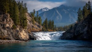
1. Bow Falls
Description
Iconic roadside waterfall on the Bow River with powerful cascades. Easy viewing platform offers great photos year-round. Featured in films.
Distance from Banff
1.5 km by road from Banff townsite (3-5 min drive).
Local Transportation
- Train: Rocky Mountaineer stops at Banff station (98 Mount Norquay Rd). Seasonal May-Oct, 2-3x/week Vancouver-Banff route. Walk 2 km or local bus to falls.
- Public transit: Roam Route 4 from Banff High School Transit Hub (May-Oct, ~5 min, $2-3 one-way). Walkable via Bow River Trail.
- Taxi: ~$10 (5 min). Via Via shuttles available.
Trail Details
1 km loop, easy, 20-30 min. Paved path with viewpoints.
Nearest Parking
Bow Falls Viewpoint lot (free, ~20 spots), 1.5 km from town center. Fills early summer—arrive before 9 AM.
Coordinates: 51.178°N, 115.570°W
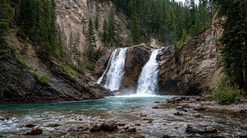
2. Johnston Canyon Lower & Upper Falls
Description
Popular catwalk trail through narrow canyon to Lower Falls (1.2 km plunge pool) and Upper Falls (40m drop). Family favorite with bridges and misty views.
Distance from Banff
25 km via Bow Valley Parkway (25-30 min drive).
Local Transportation
- Train: Rocky Mountaineer to Banff station, then bus/taxi.
- Public transit: Roam Route 9 from Banff High School Hub (May-Oct daily, weekends off-season, 30 min, $10 roundtrip) direct to trailhead.
- Taxi: ~$60-80 one-way (25 min). Pursuit shuttles available.
Trail Details
2.4 km one-way to Upper Falls, easy-moderate, 1.5-2 hrs roundtrip. Catwalks, some stairs.
Nearest Parking
Johnston Canyon Trailhead lot (free Parks Canada, 250+ spots), 25 km from town. Very busy—arrive by 7-8 AM summer.
Coordinates: 51.238°N, 115.833°W
3. Silverton Falls
Description
50m impressive summer cascade along Silverton Creek. Quieter alternative to Johnston Canyon with creek views on short forested trail.
Distance from Banff
30 km via Bow Valley Parkway (30 min drive).
Local Transportation
- Train: Rocky Mountaineer to Banff only.
- Public transit: No direct. Roam Route 9 to Johnston Canyon, then 5 km taxi/hike.
- Taxi: ~$80-100 (30 min). Private tours available.
Trail Details
2 km roundtrip, easy, 45-60 min. Old road to viewpoint.
Nearest Parking
Rockbound Lake/Silverton Falls pullout (free, ~10-20 spots), 30 km from town. Small lot—early arrival advised.
Coordinates: 51.250°N, 115.850°W
4. Cascade Falls
Description
Tall 240m cascade on Cascade Mountain, visible from highway near Cascade Ponds. Wildlife spotting area, ice climbing in winter.
Distance from Banff
6 km east on Trans-Canada Hwy (10 min drive).
Local Transportation
- Train: Rocky Mountaineer to Banff station, short taxi.
- Public transit: Roam Route 3 toward Canmore passes viewpoints (~10 min).
- Taxi: ~$20 (10 min).
Trail Details
1 km from highway to base, easy-moderate, 30 min. Grassy airstrip path.
Nearest Parking
Cascade Ponds roadside pullouts (free, informal), 6 km from town. Safe shoulder parking only.
Coordinates: 51.170°N, 115.520°W
5. Bow Glacier Falls
Description
Dramatic meltwater cascade from Bow Glacier/Wapta Icefield into Bow Lake. Glacier views on scenic meadow hike.
Distance from Banff
37 km north on Icefields Parkway (40 min drive).
Local Transportation
- Train: Rocky Mountaineer to Lake Louise (closer), then shuttle.
- Public transit: No direct. Roam 8X to Lake Louise, then taxi/tour.
- Taxi: ~$150+ (40 min). Icefields tours available.
Trail Details
9.2 km roundtrip, moderate, 2-4 hrs. Lake circuit with 155m gain.
Nearest Parking
Bow Lake Lodge parking (free, roadside), 37 km from town. Ample but busy.
Coordinates: 51.680°N, 116.850°W
6. Takakkaw Falls
Description
Canada’s second-highest at 373m. Dramatic Yoho plunge from Daily Glacier. Short walk to misty base.
Distance from Banff
93 km via Lake Louise to Yoho NP (1 hr 20 min drive).
Local Transportation
- Train: Rocky Mountaineer to Lake Louise station (closer).
- Public transit: Roam 8X to Lake Louise (1 hr), then taxi/shuttle.
- Taxi: ~$200 (1.5 hrs). Yoho tours available.
Trail Details
0.8 km roundtrip, easy, 15-20 min. Flat to viewpoint.
Nearest Parking
Takakkaw Falls lot (free Parks Canada, 100+ spots), 93 km from town. Seasonal road June-Oct, early arrival needed.
Coordinates: 51.320°N, 116.480°W
Quick Comparison Table
| Waterfall | Distance | Main Transit | Parking |
| Bow Falls | 1.5 km | Roam Route 4 | Small lot, free |
| Johnston Canyon | 25 km | Roam Route 9 | Large lot, free |
| Silverton Falls | 30 km | Route 9 + taxi | Limited pullout |
| Cascade Falls | 6 km | Roam Route 3 | Roadside free |
| Bow Glacier Falls | 37 km | Lake Louise + taxi | Roadside ample |
| Takakkaw Falls | 93 km | Lake Louise + taxi | Large lot, seasonal |
Pro Tips
- Arrive early (7-8 AM) for parking at popular trailheads
- Roam Transit Route 9 to Johnston Canyon is best value ($10 RT)
- Rocky Mountaineer provides scenic access to Banff/Lake Louise May-Oct
- Takakkaw Falls road closed winter—check Parks Canada updates
Visit our other blog on exotic tourist Locations
Banff Travel Guide: Best Time to Visit, Attractions, and Stay Options
Top 6 Things you’ll love to do in Barcelona!
Mindtrip AI: Smart AI Trip Planning Made Simple
Kutralam Travel Guide Covering Waterfalls, Temples, and Food